Weather Alert in Kansas
Flood Warning issued August 27 at 1:58PM CDT until August 31 at 3:09AM CDT by NWS Wichita KS
AREAS AFFECTED: Harvey, KS
DESCRIPTION: ...The National Weather Service in Wichita KS has issued a Flood Warning for the following rivers in Kansas... Little Arkansas River At Alta Mills affecting Reno and Harvey Counties. Little Arkansas River Near Halstead affecting Harvey County. * WHAT...Minor flooding is forecast. This approaches the flood of record. * WHERE...Little Arkansas River near Halstead. * WHEN...From Friday afternoon to early Sunday morning. * IMPACTS...At 26.0 feet, Riverside Park floods north of the river. Flood waters may begin to encroach on K89 just north of the river bridge along with a trailer park and a few residences north of Halstead. Expect field flooding on both sides of Halstead Road north of the flood gates. More field flooding occurs north of Highway 50 on the east bank of the river. Just southeast of the city, SW 48th St becomes impassable from Hertzler Rd to Essex Heights. * ADDITIONAL DETAILS... - At 12:30 PM CDT Wednesday the stage was 6.0 feet. - Forecast...The river is expected to rise above flood stage early Friday afternoon to a crest of 26.2 feet early Saturday morning. It will then fall below flood stage Saturday afternoon. - Flood stage is 25.0 feet.
INSTRUCTION: Do not drive into flooded areas or go around barricades. Nearly two feet of water will carry most vehicles away. Turn around, don't drown. Additional information is available at www.weather.gov. The next statement will be issued late tonight at 200 AM CDT.
Want more detail? Get the Complete 7 Day and Night Detailed Forecast!
Current U.S. National Radar--Current
The Current National Weather Radar is shown below with a UTC Time (subtract 5 hours from UTC to get Eastern Time).

National Weather Forecast--Current
The Current National Weather Forecast and National Weather Map are shown below.

National Weather Forecast for Tomorrow
Tomorrow National Weather Forecast and Tomorrow National Weather Map are show below.

North America Water Vapor (Moisture)
This map shows recent moisture content over North America. Bright and colored areas show high moisture (ie, clouds); brown indicates very little moisture present; black indicates no moisture.

Weather Topic: What is Graupel?
Home - Education - Precipitation - Graupel
 Next Topic: Hail
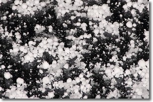
Graupel is a form of precipitation that is created by atmospheric conditions
which cause supercooled water droplets to contact snow crystals and freeze to
their surface.
Sometimes known as soft hail or snow pellets, graupel is delicate and easily
destroyed by touch. Whereas hail usually falls during severe weather, graupel
doesn't require such conditions to form, and can form in mild precipitation
similar to situations which produce snowfall.
Next Topic: Hail
Weather Topic: What are Hole Punch Clouds?
Home - Education - Cloud Types - Hole Punch Clouds
 Next Topic: Mammatus Clouds
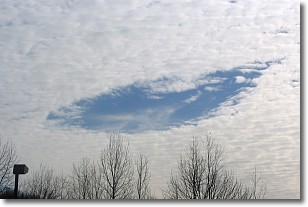
A hole punch cloud is an unusual occurrence when a disk-shaped
hole appears in a cirrostratus, cirrocumulus, or altocumulus cloud.
When part of the cloud forms ice crystals, water droplets in the surrounding area
of the cloud evaporate. The effect of this process produces a large elliptical
gap in the cloud. The hole punch cloud formation is rare, but it is not specific
to any geographic area.
Other names which have been used to describe this phenomena include fallstreak hole,
skypunch, and cloud hole.
Next Topic: Mammatus Clouds
Current conditions powered by WeatherAPI.com


