Weather Alert in Texas
Flood Advisory issued July 9 at 2:51PM CDT until July 9 at 4:45PM CDT by NWS San Angelo TX
AREAS AFFECTED: Brown, TX; Coleman, TX; McCulloch, TX; San Saba, TX
DESCRIPTION: * WHAT...Flooding caused by excessive rainfall is expected. * WHERE...A portion of west central Texas, including the following counties, far southern Brown, far southern Coleman, northern McCulloch and northern San Saba Counties. * WHEN...Until 445 PM CDT. * IMPACTS...Flooding in low-lying and poor drainage areas. * ADDITIONAL DETAILS... - At 245 PM CDT, Doppler radar indicated an east to west band of showers and thunderstorms with very heavy rain, extending across the far northern parts of San Saba McCulloch, and far southern Coleman and extreme southern Brown Counties. This band of showers and storms was moving verly slowly south at 10 mph. Flooding is ongoing or expected to begin shortly in the advisory area. Between 1 and 2 inches of rain have already fallen. - Additional rainfall amounts of 0.5 to 1.5 inches are expected over the area. This additional rain on saturated ground will result in flooding, especially in low-lying areas. Street flooding is likely in the towns of Rockwood, Winchell, Elm Grove and Spring Creek. - Some locations that will experience flooding include... Mercury, Winchell, Elm Grove, Skeeterville, Rockwood, Waldrip, Gouldbusk, Milburn, Whon, Us-283 Near The Mcculloch- Coleman County Line, Locker and Spring Creek. - http://www.weather.gov/safety/flood
INSTRUCTION: Turn around, don't drown when encountering flooded roads. Most flood deaths occur in vehicles.
Want more detail? Get the Complete 7 Day and Night Detailed Forecast!
Current U.S. National Radar--Current
The Current National Weather Radar is shown below with a UTC Time (subtract 5 hours from UTC to get Eastern Time).

National Weather Forecast--Current
The Current National Weather Forecast and National Weather Map are shown below.

National Weather Forecast for Tomorrow
Tomorrow National Weather Forecast and Tomorrow National Weather Map are show below.

North America Water Vapor (Moisture)
This map shows recent moisture content over North America. Bright and colored areas show high moisture (ie, clouds); brown indicates very little moisture present; black indicates no moisture.

Weather Topic: What are Shelf Clouds?
Home - Education - Cloud Types - Shelf Clouds
 Next Topic: Sleet
A shelf cloud is similar to a wall cloud, but forms at the front
of a storm cloud, instead of at the rear, where wall clouds form.
A shelf cloud is caused by a series of events set into motion by the advancing
storm; first, cool air settles along the ground where precipitation has just fallen.
As the cool air is brought in, the warmer air is displaced, and rises above it,
because it is less dense. When the warmer air reaches the bottom of the storm cloud,
it begins to cool again, and the resulting condensation is a visible shelf cloud.
Next Topic: Sleet
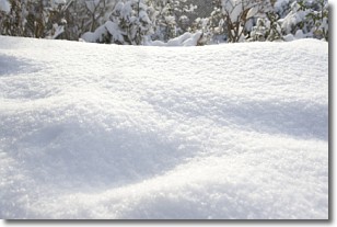
Weather Topic: What is Snow?
Home - Education - Precipitation - Snow
 Next Topic: Stratocumulus Clouds
Snow is precipitation taking the form of ice crystals. Each ice crystal, or snowflake,
has unique characteristics, but all of them grow in a hexagonal structure.
Snowfall can last for sustained periods of time and result in significant buildup
of snow on the ground.
On the earth's surface, snow starts out light and powdery, but as it begins to melt
it tends to become more granular, producing small bits of ice which have the consistency of
sand. After several cycles of melting and freezing, snow can become very dense
and ice-like, commonly known as snow pack.
Next Topic: Stratocumulus Clouds
Current conditions powered by WeatherAPI.com


