Weather Alert in Washington
Red Flag Warning issued August 25 at 6:32AM PDT until August 26 at 9:00PM PDT by NWS Spokane WA
AREAS AFFECTED: East Washington Central Cascades; East Portion of North Cascades National Park / Lake Chelan National Recreation Area; East Washington North Cascades; Methow Valley
DESCRIPTION: ...HOT, DRY, AND UNSTABLE CONDITIONS FOR MONDAY AND TUESDAY ALONG WITH THE POTENTIAL FOR ISOLATED THUNDERSTORMS WITH GUSTY OUTFLOW WINDS... .Hot, dry, and unstable conditions are forecast along the East Slopes of the Central and Northern Cascades as well as the Methow Valley Monday and Tuesday. In addition, we are monitoring the potential for isolated thunderstorms on Monday and Tuesday afternoons that could result in new fire starts along with gusty outflow winds. * Affected Area: East Washington Central Cascades (Zone 696), East Portion of North Cascades National Park/Lake Chelan National Recreation Area (Zone 697), East Washington North Cascades (Zone 698) and Methow Valley (Zone 704). * Winds: Southeast around 5 mph in the afternoon shifting to northwest in the evening, except gusty outflow winds near thunderstorms. * Timing: Afternoon and evening for both Monday and Tuesday. * Relative Humidities: Below 4000 feet: 13 to 20 percent. Above 4000 feet: 20 to 30 percent. * Temperatures: Below 4000 feet: 90 to 102 degrees. Above 4000 feet: 75 to 90 degrees. * Lightning: A 5-10 percent chance of dry thunderstorms late Monday afternoon into the evening. A 20-25 percent chance of thunderstorms Tuesday afternoon and evening mainly over the higher terrain. * Impacts: Hot, dry, unstable conditions may lead to rapid fire growth on any new or existing fires. Isolated thunderstorms will bring the potential for new fire starts, as well as gusty outflow winds.
INSTRUCTION: A Red Flag Warning means that critical fire weather conditions are either occurring now....or will shortly.
Want more detail? Get the Complete 7 Day and Night Detailed Forecast!
Current U.S. National Radar--Current
The Current National Weather Radar is shown below with a UTC Time (subtract 5 hours from UTC to get Eastern Time).

National Weather Forecast--Current
The Current National Weather Forecast and National Weather Map are shown below.

National Weather Forecast for Tomorrow
Tomorrow National Weather Forecast and Tomorrow National Weather Map are show below.

North America Water Vapor (Moisture)
This map shows recent moisture content over North America. Bright and colored areas show high moisture (ie, clouds); brown indicates very little moisture present; black indicates no moisture.

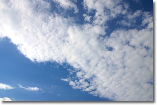
Weather Topic: What are Stratus Clouds?
Home - Education - Cloud Types - Stratus Clouds
 Next Topic: Wall Clouds
Stratus clouds are similar to altostratus clouds, but form at a
lower altitude and are identified by their fog-like appearance, lacking the
distinguishing features of most clouds.
Stratus clouds are wider than most clouds, and their base has a smooth, uniform
look which is lighter in color than a nimbostratus cloud.
The presence of a stratus cloud indicates the possibility of minor precipitation,
such as drizzle, but heavier precipitation does not typically arrive in the form
of a stratus cloud.
Next Topic: Wall Clouds
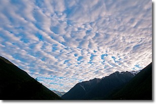
Weather Topic: What are Altocumulus Clouds?
Home - Education - Cloud Types - Altocumulus Clouds
 Next Topic: Altostratus Clouds
Similar to cirrocumulus clouds, altocumulus clouds are
characterized by cloud patches. They are distinguished by larger cloudlets
than cirrocumulus clouds but are still smaller than stratocumulus clouds.
Altocumulus clouds most commonly form in middle altitudes (between 2 and 5 km)
and may resemble, at times, the shape of a flying saucer.
These uncommon formations, called altocumulus lenticularis, are created by uplift
in the atmosphere and are most often seen in close proximity to mountains.
Next Topic: Altostratus Clouds
Current conditions powered by WeatherAPI.com


