Weather Alert in Alaska
Flood Watch issued August 27 at 2:07PM AKDT until August 29 at 10:00AM AKDT by NWS Anchorage AK
AREAS AFFECTED: Southern Kenai Mtns
DESCRIPTION: * WHAT...Flooding caused by excessive rainfall is possible. 3 to 5 inches of rainfall. * WHERE...The following area, Southern Kenai Mtns. This includes the city of Seward. * WHEN...From 10 PM AKDT this evening through Friday morning. * IMPACTS...Excessive runoff may result in flooding of rivers, creeks, streams, and other low-lying and flood-prone locations. Creeks and streams may rise out of their banks. Flooding may occur in poor drainage and urban areas. Low-water crossings may be flooded. Landslides may possible in areas of steep terrain. Ponding on roadways may result in hydroplaning. * ADDITIONAL DETAILS... - A multi-day rainfall event is underway across Southcentral Alaska. Rainfall totals are generally expected to range between 3 and 5 inches for Seward, Bear Creek, and nearby areas. Locally higher amounts possible in higher terrain. Rain is expected to taper off during the day on Friday, though high water is likely to persist into the weekend. - Http://www.weather.gov/safety/flood
INSTRUCTION: Persons living along streams should stay alert and be prepared to take action if a warning or advisory is issued, or flooding is observed. You should monitor later forecasts and be alert for possible Flood Warnings. Those living in areas prone to flooding should be prepared to take action should flooding develop. Stay tuned to further developments by listening to your local radio, television, or NOAA Weather Radio for further information.
Want more detail? Get the Complete 7 Day and Night Detailed Forecast!
Current U.S. National Radar--Current
The Current National Weather Radar is shown below with a UTC Time (subtract 5 hours from UTC to get Eastern Time).

National Weather Forecast--Current
The Current National Weather Forecast and National Weather Map are shown below.

National Weather Forecast for Tomorrow
Tomorrow National Weather Forecast and Tomorrow National Weather Map are show below.

North America Water Vapor (Moisture)
This map shows recent moisture content over North America. Bright and colored areas show high moisture (ie, clouds); brown indicates very little moisture present; black indicates no moisture.

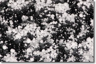
Weather Topic: What is Graupel?
Home - Education - Precipitation - Graupel
 Next Topic: Hail
Graupel is a form of precipitation that is created by atmospheric conditions
which cause supercooled water droplets to contact snow crystals and freeze to
their surface.
Sometimes known as soft hail or snow pellets, graupel is delicate and easily
destroyed by touch. Whereas hail usually falls during severe weather, graupel
doesn't require such conditions to form, and can form in mild precipitation
similar to situations which produce snowfall.
Next Topic: Hail
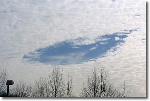
Weather Topic: What are Hole Punch Clouds?
Home - Education - Cloud Types - Hole Punch Clouds
 Next Topic: Mammatus Clouds
A hole punch cloud is an unusual occurrence when a disk-shaped
hole appears in a cirrostratus, cirrocumulus, or altocumulus cloud.
When part of the cloud forms ice crystals, water droplets in the surrounding area
of the cloud evaporate. The effect of this process produces a large elliptical
gap in the cloud. The hole punch cloud formation is rare, but it is not specific
to any geographic area.
Other names which have been used to describe this phenomena include fallstreak hole,
skypunch, and cloud hole.
Next Topic: Mammatus Clouds
Current conditions powered by WeatherAPI.com


