Weather Alert in Hawaii
High Surf Warning issued February 6 at 3:36PM HST until February 7 at 6:00PM HST by NWS Honolulu HI
AREAS AFFECTED: Maui Windward West; Maui Central Valley North; Windward Haleakala
DESCRIPTION: ...HIGH SURF WARNING FOR NORTH AND WEST FACING SHORES OF NIIHAU KAUAI OAHU AND MOLOKAI AND FOR NORTH FACING SHORES OF MAUI THROUGH 6 PM HST SATURDAY... ...HIGH SURF ADVISORY FOR WEST FACING SHORES OF THE BIG ISLAND FROM 6 AM HST SATURDAY THROUGH 6 PM HST SATURDAY... .A large west-northwest to northwest swell (295-315 degrees) will build down the island chain through the evening and peak late tonight into early Saturday. The swell will decline sharply Saturday afternoon and evening, with surf expected to fall below headline levels by Sunday morning. * WHAT...Along north facing shores of Maui, surf building to 18 to 25 feet tonight and continuing into Saturday morning. * WHERE...North facing shores of Maui. * WHEN...Until 6 PM HST Saturday. * IMPACTS...High. Expect very strong breaking waves and powerful currents. Waves breaking in channel entrances may make navigating the channels dangerous.
INSTRUCTION: Stay away from the shoreline along the affected coasts. Be prepared for road closures. Postpone entering or leaving channels affected by the high surf until the surf subsides.
Want more detail? Get the Complete 7 Day and Night Detailed Forecast!
Current U.S. National Radar--Current
The Current National Weather Radar is shown below with a UTC Time (subtract 5 hours from UTC to get Eastern Time).

National Weather Forecast--Current
The Current National Weather Forecast and National Weather Map are shown below.

National Weather Forecast for Tomorrow
Tomorrow National Weather Forecast and Tomorrow National Weather Map are show below.

North America Water Vapor (Moisture)
This map shows recent moisture content over North America. Bright and colored areas show high moisture (ie, clouds); brown indicates very little moisture present; black indicates no moisture.

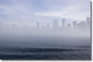
Weather Topic: What is Fog?
Home - Education - Cloud Types - Fog
 Next Topic: Fractus Clouds
Fog is technically a type of stratus cloud, which lies along the
ground and obscures visibility.
It is usually created when humidity in the air condenses into tiny water droplets.
Because of this, some places are more prone to foggy weather, such as regions
close to a body of water.
Fog is similar to mist; both are the appearance of water droplets suspended in
the air, but fog is the term applied to the condition when visibility is less than 1 km.
Next Topic: Fractus Clouds
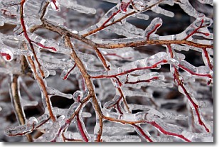
Weather Topic: What is Freezing Rain?
Home - Education - Precipitation - Freezing Rain
 Next Topic: Graupel
Freezing rain is a condition where precipitation which has fallen in the form of
water droplets reaches temperatures which are below freezing and freezes upon
coming into contact
with surface objects. The result of this precipitation is a glaze of ice which
can be damaging to plants and man-made structures. A severe onset of freezing
rain which results in a very thick glaze of ice is known as an ice storm.
Next Topic: Graupel
Current conditions powered by WeatherAPI.com


