Weather Alert in Florida
Flood Warning issued August 25 at 9:06PM EDT until August 28 at 2:00PM EDT by NWS Melbourne FL
AREAS AFFECTED: Lake, FL; Volusia, FL
DESCRIPTION: ...The Flood Warning continues for the following rivers in Florida... St Johns River Near Astor affecting Volusia and Lake Counties. .Heavy rain and saturated soils in the Middle Saint Johns basin have led to a steady rise in river levels near Astor. Levels are forecast to slowly rise to Minor Flood Stage within the next day, and remain steady through mid to late week. For the St. Johns River...including Astor...Minor flooding is forecast. Additional information is available at www.weather.gov. The next statement will be issued Tuesday afternoon at noon EDT. * WHAT...Minor flooding is forecast. * WHERE...St Johns River near Astor. * WHEN...From Tuesday morning to early Thursday afternoon. * IMPACTS...At 2.3 feet, Many docks become submerged along the river and in canals in the Astor community. Water enters yards of properties on Bartram Road, Holiday Circle and along Wild Hog Road on the Lake County side. In Volusia County, water encroaches yards of homes on the river side of Alice Drive. No wake zones are in effect from near the South Moon Canal to approximately 800 feet south of the Riverview lodge. * ADDITIONAL DETAILS... - At 8:30 PM EDT Monday the stage was 2.2 feet. - Bankfull stage is 2.0 feet. - Forecast...The river is expected to rise to a crest of 2.3 feet tomorrow morning. It will then fall below flood stage Thursday morning. - Flood stage is 2.3 feet. - http://www.weather.gov/safety/flood
INSTRUCTION: N/A
Want more detail? Get the Complete 7 Day and Night Detailed Forecast!
Current U.S. National Radar--Current
The Current National Weather Radar is shown below with a UTC Time (subtract 5 hours from UTC to get Eastern Time).

National Weather Forecast--Current
The Current National Weather Forecast and National Weather Map are shown below.

National Weather Forecast for Tomorrow
Tomorrow National Weather Forecast and Tomorrow National Weather Map are show below.

North America Water Vapor (Moisture)
This map shows recent moisture content over North America. Bright and colored areas show high moisture (ie, clouds); brown indicates very little moisture present; black indicates no moisture.

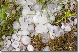
Weather Topic: What is Hail?
Home - Education - Precipitation - Hail
 Next Topic: Hole Punch Clouds
Hail is a form of precipitation which is recognized by large solid balls or
clumps of ice. Hail is created by thunderstorm clouds with strong updrafts of wind.
As the hailstones remain in the updraft, ice is deposited onto them until their
weight becomes heavy enough for them to fall to the earth's surface.
Hail storms can cause significant damage to crops, aircrafts, and man-made structures,
despite the fact that the duration is usually less than ten minutes.
Next Topic: Hole Punch Clouds
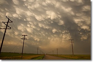
Weather Topic: What are Mammatus Clouds?
Home - Education - Cloud Types - Mammatus Clouds
 Next Topic: Nimbostratus Clouds
A mammatus cloud is a cloud with a unique feature which resembles
a web of pouches hanging along the base of the cloud.
In the United States, mammatus clouds tend to form in the warmer months, commonly
in the Midwest and eastern regions.
While they usually form at the bottom of a cumulonimbis cloud, they can also form
under altostratus, altocumulus, stratocumulus, and cirrus clouds. Mammatus clouds
warn that severe weather is close.
Next Topic: Nimbostratus Clouds
Current conditions powered by WeatherAPI.com


