Weather Alert in Minnesota
Fire Weather Watch issued May 10 at 2:35AM CDT until May 11 at 10:00PM CDT by NWS Grand Forks ND
AREAS AFFECTED: Norman; Clay; South Beltrami; Mahnomen; South Clearwater; Hubbard; West Becker; East Becker; Wilkin; West Otter Tail; East Otter Tail; Wadena; Grant; Griggs; Steele; Traill; Barnes; Cass; Ransom; Sargent; Richland
DESCRIPTION: * AFFECTED AREA...In Minnesota, Norman, Clay, South Beltrami, Mahnomen, South Clearwater, Hubbard, West Becker, East Becker, Wilkin, West Otter Tail, East Otter Tail, Wadena and Grant. In North Dakota, Griggs, Steele, Traill, Barnes, Cass, Ransom, Sargent and Richland. * WINDS...South 20 to 30 mph with gusts up to 45 mph. * RELATIVE HUMIDITY...As low as 18 percent. * IMPACTS...Any fires that ignite will spread rapidly and become difficult to control. Outdoor burning is not recommended. * ADDITIONAL DETAILS...Southerly winds will continue to increase over the weekend, with extremely warm temperatures arriving by Sunday. The hot temperatures, low relative humidity values, and strong southerly winds could bring critical fire weather conditions Sunday afternoon.
INSTRUCTION: A Fire Weather Watch means that critical fire weather conditions are forecast to occur. Listen for later forecasts and possible Red Flag Warnings.
Want more detail? Get the Complete 7 Day and Night Detailed Forecast!
Current U.S. National Radar--Current
The Current National Weather Radar is shown below with a UTC Time (subtract 5 hours from UTC to get Eastern Time).

National Weather Forecast--Current
The Current National Weather Forecast and National Weather Map are shown below.

National Weather Forecast for Tomorrow
Tomorrow National Weather Forecast and Tomorrow National Weather Map are show below.

North America Water Vapor (Moisture)
This map shows recent moisture content over North America. Bright and colored areas show high moisture (ie, clouds); brown indicates very little moisture present; black indicates no moisture.

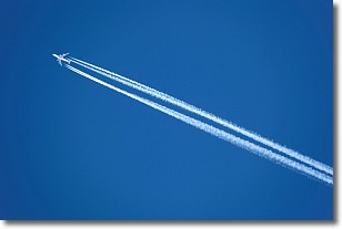
Weather Topic: What are Contrails?
Home - Education - Cloud Types - Contrails
 Next Topic: Cumulonimbus Clouds
A contrail is an artificial cloud, created by the passing of an
aircraft.
Contrails form because water vapor in the exhaust of aircraft engines is suspended
in the air under certain temperatures and humidity conditions. These contrails
are called exhaust contrails.
Another type of contrail can form due to a temporary reduction in air pressure
moving over the plane's surface, causing condensation.
These are called aerodynamic contrails.
When you can see your breath on a cold day, it is also because of condensation.
The reason contrails last longer than the condensation from your breath is
because the water in contrails freezes into ice particles.
Next Topic: Cumulonimbus Clouds
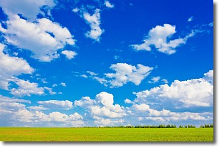
Weather Topic: What are Cumulus Clouds?
Home - Education - Cloud Types - Cumulus Clouds
 Next Topic: Drizzle
Cumulus clouds are fluffy and textured with rounded tops, and
may have flat bottoms. The border of a cumulus cloud
is clearly defined, and can have the appearance of cotton or cauliflower.
Cumulus clouds form at low altitudes (rarely above 2 km) but can grow very tall,
becoming cumulus congestus and possibly the even taller cumulonimbus clouds.
When cumulus clouds become taller, they have a greater chance of producing precipitation.
Next Topic: Drizzle
Current conditions powered by WeatherAPI.com


